Overview
Digital mapping has quickly become a staple of the literature and writing classroom, but it can also provide a means of inquiry for any area of study where spatial visualization enhances a student’s understanding of a text or topic. For instance, a Women’s and Gender Studies course might ask students to map feminist movements across a city, state, country, or the world. This kind of assignment can easily integrate questions of temporality by asking students to take into account dates as they map the movement across national boundaries. HistoryPin, a user-friendly platform, offers an example of what this might look like.
Why do this?
Mapping a novel (a character’s spatiotemporal trajectory through her plot), a poem (its landmarks and other spatial references), or an author’s references to places across her work provides students with an opportunity to develop their close reading skills by asking them to pay careful attention to essential literary features: space, time, plot and story. By adding a research component, students can be tasked to investigate details on specific places (e.g., when a monument was built or who attended specific venues that the character visits). They can be asked to add images to accompany pins or points on a map. In addition, the assignment can ask students to write a gloss, or short description or explanation, to accompany the pins and image, and thereby further their understanding of a text’s environmental, cultural, political, and social context. Asking students to write short glosses for each place they locate simultaneously allows them to synthesize information and create an explicit and clear connection back to the novel, the plot and its relationship to the story.
Google Maps
If this is your first time trying out this kind of assignment, we recommend starting with Google Maps. Students can easily produce two-dimensional maps on their own or in groups, and share them with instructors for feedback and grading.
As you gain confidence with Google Maps, you can develop websites like this one on James Joyce’s Ulysses (using Google sites or other website platforms) that require students to develop a more comprehensive exploration of a given text.
Adeline Koh (Stockton University) offers useful commentary and some guidelines on both mapping novels like Ulysses and how to map texts which don’t provide specific street names or details as a means of collaboratively close reading a novel.
Google Maps Assignment Example
Jodi Wyett (English, Xavier University) has created this assignment template which can be easily adapted to any course and which provides a useful guide for how to use Google Maps. This assignment can be easily adapted for Google Earth.
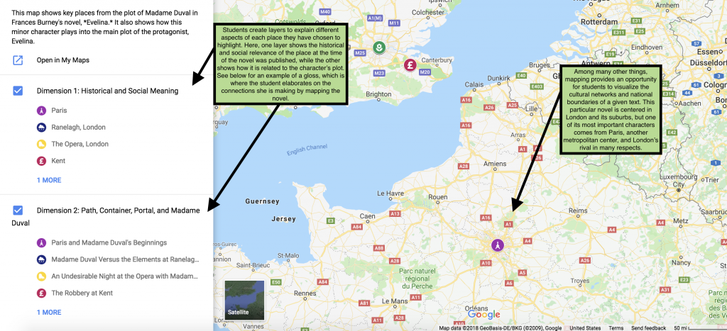
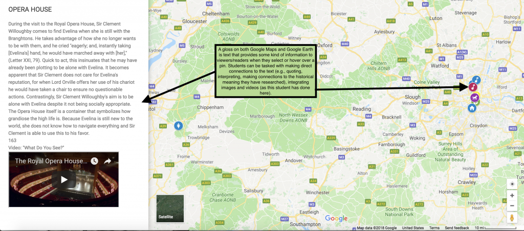
Below two screenshots from a Google Map assignment created at PLU show what a simple map might look like and highlight two interrelated functions of Google Maps: Layers and Glosses.
Layers: By asking students to create different layers, it is possible for them to identify, for instance, the historical or geographical aspects of a particular place they have chosen to highlight. And then, in a different layer, to highlight this place’s textual relevance for the novel. Students can visually link the places to each other by choosing colors and icons that signal the relationship between a single place in each layer. The example we have provided below is from an assignment that asked students to create two layers: one where they focused on the historical and social relevance of a particular place, and one where they focused on the character’s plot.
Gloss: The gloss is crucial to clarify the connections that students will signal through the color and/or icons they choose for each place. Glosses are concise texts that students write to accompany their pins. The gloss in each layer will carefully explain the relevance of each place paying particular attention to that layer’s central theme. So, for instance, on the example below, the gloss belongs the second layer where students are expected to make connections between the place and the novel’s plot. Using her research on the eighteenth-century opera, the student can then develop an interpretation of why this particular character experiences a particular event at the opera and not, for instance, at a café or at a park. Glosses can include quotations from the novel and can also include images (more than one) and videos.
Google Earth
Once you feel comfortable with Google Maps or if you’ve already used Google Maps before, Google Earth is just a few steps ahead, allowing students to produce three-dimensional maps. Using Google Earth will require you (and your students) to download the software. If students can’t download Google Earth, they can use the DH Lab computers to create their assignments.
Erin Sells (Lander University) provides links to resources and explains her own Google Earth assignment here.
Google Earth and Other Resources
There are many resources available to get you started on Google Earth on YouTube’s Google Earth channel. We recommend beginning with this tutorial.
A very useful and free resource that provides many examples of literature maps created for high school and higher education courses is Google Lit Trips. They require that you register in order to see the examples.
In addition to Google Earth, MapScholar now provides a free geospatial tool designed with academics in mind. You can find their handy developer guide here, to get a sense of what teaching with MapScholar would involve.


